
How Could Your Operation Benefit from Imagery?

They say “a picture is worth a 1,000 words” but I like to say a good image is worth thousands of dollars. The term “imagery” gets thrown around so much in the precision ag realm that many of us gloss over the term and really don’t consider the full value it can bring to our operations.
Imagery in precision agriculture encompasses a vast array of valuable pictures, most of which originate from either satellites, airplanes, or UAVs (drones). The difference between these three sources is frequency and resolution. Airplanes and drones can fly essentially on command — unless it’s a cloudy day — while a satellite is fixed in orbit. In addition, airplanes and drones tend to have higher resolution than most satellites.
So how can we get value from these fancy pictures? If you have flown in a small airplane or piloted a drone, you know it provides a convenient
perspective. You can truly learn a lot from one snapshot of your field, as problem areas stand out due to differences in the amount of biomass or even a color variation if the crop is really stressed.
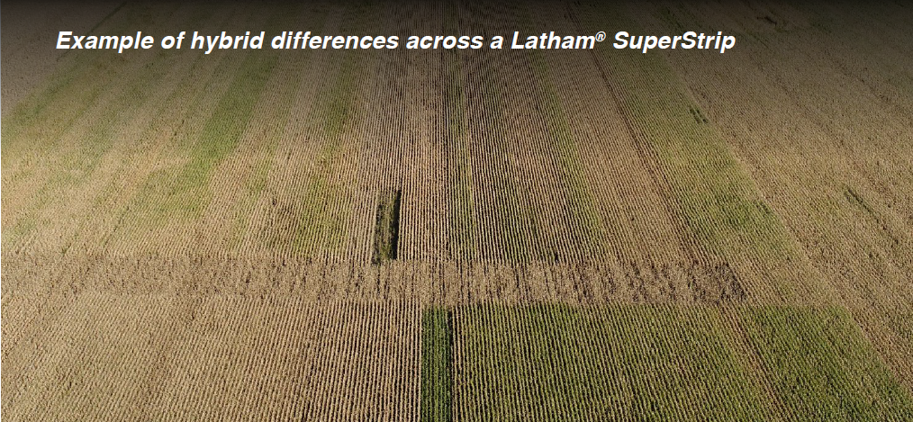
In this drone image taken in Alexander, Iowa, you can see hybrid differences across a Latham® SuperStrip and where the planter ran out of seed. You also can note poorer spots in the field where there is frequent ponding or a germination issue due to planting date, soil type influences, and so on. Without imagery, many of these problems wouldn’t be revealed until harvest.
Another use for satellite or aerial imagery is for crop insurance claims or other crop damage. You may have a 270-acre corn field that was hit by hail during the tassel stage. It would be almost impossible to scout thoroughly on foot at that stage; however, an aerial image shows which areas received the most damage. You could use such a drone image to selectively scout that field instead of taking a whole day trying to walk it on foot. After all, time is money!
To enhance our crop scouting abilities, we use crop health images. A vegetative index allows us to compare crops across the season
and even across multiple seasons and multiple crops. Crop health images also may be related to yield at the end of the season by (1) creating Production/Management zone maps to use for variable or burned up, depending on their topography. You might decide to go without production on that acre or put it in a government program to still make money on it. If it is a drainage issue, it might be time for additional tile.
That reminds me of another use for imagery when it comes to tiling… you can use aerial imagery within a few hours or days of a heavy
rain event when there isn’t a crop on the field. This gives you a better understanding of how your field drains. Thermal imaging is also used for this purpose.
Hopefully, I’ve given you enough reasons to pique your interest about how imagery could benefit your operation by adding thousands of dollars to your bottom line by either saving inputs or increasing yield. Feel free to call me if you’re interested in learning more about imagery.